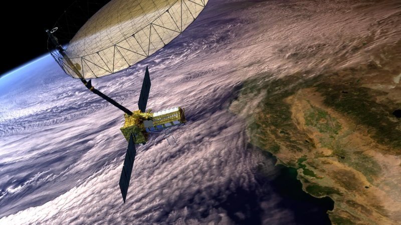
The NASA-ISRO Synthetic Aperture Radar (NISAR) satellite, a joint Earth-observation mission between NASA and the Indian Space Research Organisation (ISRO), is slated for launch from India in early 2025. This cutting-edge mission is designed to monitor Earth’s surface movements with remarkable precision, targeting regions prone to natural hazards such as earthquakes, landslides, and volcanic activity. By detecting surface shifts as subtle as fractions of an inch, NISAR aims to enhance our understanding of Earth’s dynamic processes and contribute to disaster preparedness and infrastructure management.
Equipped with state-of-the-art radar systems, NISAR will feature advanced L-band and S-band technology to survey nearly all land and ice-covered areas on the planet twice within a 12-day period. NASA’s Jet Propulsion Laboratory (JPL) has developed the L-band radar system, which can penetrate dense vegetation to detect subtle surface changes, while ISRO’s S-band radar enhances the satellite’s imaging capabilities. Operating continuously, regardless of weather or lighting conditions, the satellite ensures a comprehensive flow of data. According to Cathleen Jones, the mission’s applications lead at JPL, this capability will allow for consistent monitoring of critical areas.
NISAR’s ability to reveal fine ground movements is particularly valuable for assessing earthquake-prone regions. While it will not predict earthquakes, the satellite’s data can pinpoint areas where tectonic faults are locked and more likely to experience seismic activity, as highlighted by Mark Simons, the U.S. Solid Earth Science Lead for the project. Beyond natural disaster monitoring, the satellite will also play a significant role in observing infrastructure. Its consistent data collection over time will support assessments of dams, levees, and aqueducts, helping resource managers identify potential vulnerabilities remotely. This approach reduces the need for costly manual inspections, as demonstrated in applications like monitoring earthquake-related impacts on the levees of the Sacramento-San Joaquin River Delta.
As the first Earth-observing technology jointly developed by NASA and ISRO, the mission represents a unique collaboration. NASA has contributed components like radar systems and communication subsystems, while ISRO has taken charge of the satellite bus, launch services, and mission operations. By merging technological expertise and scientific objectives, NISAR is poised to provide invaluable insights into Earth’s movements, advancing global research and infrastructure safety initiatives.
Topics #2025 #Collaboration #Earth #India #Isro #NASA #news #NISAR #Partnership #Satellite #solar system #space #Universe #USA


